Day nine: Port Isaac, 19th December 2008
I picked a mostly overcast, not-too-cold day just before Christmas for the latest stage of my effort to see every last nook and cranny of Cornwall. It was a perfect temperature to wear my University of Wales, Aberystwyth walking club top, a garment which hasn’t come in handy for several years (maybe I am going into too much detail on these blog postings!)
I skipped quite a bit of coast as there are actually no settlements at all on the coast for a few miles, so I will come back to the likes of Delabole later on.
I drove down the extremely steep road to the tiny fishing village of Port Quin. I was interested to read that this is sometimes known as the “village that died”, as it was twice abandoned, once because the pilchards failed and once because all the men died at sea in a big storm. That gives you an idea of its remoteness for a start. The village today consists of four or five very large houses (some of these are National Trust properties) down by the sea. It’s not really a working port any more with just the odd boat coming in from time to time. It is absolutely gorgeous. It is both very sleepy and, at times I’m sure, very stormy. As a “get away from it all” type place in Cornwall, I’ve found none better.  From Port Quin to Port Isaac, the coastal walk is exceptional. The ascents are steep and unforgiving, although not rising as high as the cliffs further north in Cornwall. The three mile walk took me nearly an hour and a half, giving an idea of the toughness of the terrain. The sea was rough and the waves crashing against the rocks were simply spectacular in places.
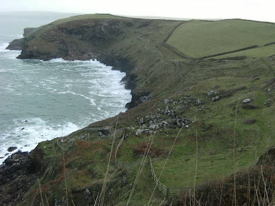 This is one of those sections of coast where you feel like you could be 20 miles away from the next person; off the beaten track and remote, this is not for the average tourist.
From Port Quin to Port Isaac, the coastal walk is exceptional. The ascents are steep and unforgiving, although not rising as high as the cliffs further north in Cornwall. The three mile walk took me nearly an hour and a half, giving an idea of the toughness of the terrain. The sea was rough and the waves crashing against the rocks were simply spectacular in places. This is one of those sections of coast where you feel like you could be 20 miles away from the next person; off the beaten track and remote, this is not for the average tourist.Port Isaac seemed to take ages to come but when it did, what a treat! It’s no wonder ITV decided to film Doc Martin here, but what a pity they didn’t do their research on the local accent, the characters all sounded like they were from rural Somerset. I had to wonder what all the genuine Cornish fisherman (and there’s still a lot of them here) thought about all these outsiders milling around talking like the Wurzels! I also wonder what disruption was caused to the fishing industry and local businesses and whether any compensation was provided for this with film crews etc blocking the narrow streets. The drama series has probably boosted tourism anyway. Another series is going to be filmed from May 2009. I took a photo of Doc Martin’s cottage and wondered how much ITV would let it go for.
 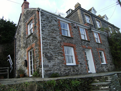 They would probably laugh at me if I offered ten million pounds, making it perhaps the most expensive dwelling in Cornwall. Sitting down at the harbour, it occurred to me that I could easily be on the West coast of Scotland or Ireland, such was the magnitude of the cliffs sheltering the harbour. Incredible.
It’s no wonder ITV decided to film Doc Martin here, but what a pity they didn’t do their research on the local accent, the characters all sounded like they were from rural Somerset. I had to wonder what all the genuine Cornish fisherman (and there’s still a lot of them here) thought about all these outsiders milling around talking like the Wurzels! I also wonder what disruption was caused to the fishing industry and local businesses and whether any compensation was provided for this with film crews etc blocking the narrow streets. The drama series has probably boosted tourism anyway. Another series is going to be filmed from May 2009. I took a photo of Doc Martin’s cottage and wondered how much ITV would let it go for. They would probably laugh at me if I offered ten million pounds, making it perhaps the most expensive dwelling in Cornwall. Sitting down at the harbour, it occurred to me that I could easily be on the West coast of Scotland or Ireland, such was the magnitude of the cliffs sheltering the harbour. Incredible.I briefly visited the church, the only one in Port Isaac, and carried on to my third settlement, and third port, of the day. Port Gaverne is Isaac’s much smaller sister village. I had always thought it was just a couple of houses on the sea front, but walking up behind, I found quite a few more. I had to walk up past these to go inland for the first time, up a steep hill on a muddy footpath to the hamlet of Trewetha. Nothing much here, just a few houses and a farm on a bend of the main B-road into Port Isaac. I continued along this road for about half a mile before coming off-road again to go over some fields. I found myself next to a newly built house. A quick check of the map; yes the right of way does go up over the slope in front of me and straight across the field. I proceed, when suddenly “Oi, where do you think you’re going?” comes from a voice with a Cornish accent. “It’s a right of way, mate” I reply. My initial defiance annoys him and he beckons me over for a chat. I happily oblige, I know I’m in the right. He’s a tall chap, threatening, confrontational and rather aggressive, probably in his fifties. He explains that I should be heading round the edge of the field, not straight across it. To head around it would mean going through thick undergrowth, it didn’t even appear obvious I could get through. The altercation lasted about ten minutes and included exchanges such as “I’m just trying to get into the mind of a walker to try to work out what would possess you to go that way”, “well the fact that it looks well walked and that is where the right of way is marked on my map” was my reply. He claimed that 80% of rights of way on OS maps were wrong. In making absurd claims like this, I knew I had him on the ropes. I told him that in years of doing walks like this, I had never got on the wrong side of another landowner. He seemed absolutely taken back by this and I think he finally realised that I wasn’t one of these people who mindlessly walks wherever they like. The conversation ended – rather bizarrely - by him telling me I was a good man, and me – even more bizarrely – saying “I think I’m a good man too”. I set off round the edge of the field (where, incidentally there is no right of way marked), but it will not change my approach to rights of way in the future. It’s refreshing to know that there are still Cornishmen roaming around Cornwall quite literally shouting “get orf moi land” to unsuspecting walkers. Joking aside though, it’s actually pretty sad that instead of simply making a sign, some people will use up their time and energy picking a fight with people enjoying themselves in the great outdoors following legally defined paths.
The ironic thing is, that after my altercation with said Cornishman, this was playing on my mind and my navigation did actually go wrong. I ended up finding my way through fields (definitely not on a right of way!) to the B3314, the main artery for the small villages in this part of North Cornwall. I walked along here to the village of Pendoggett, yet another settlement with a recently converted church. I turned right down a track, finding more housing than was marked on the map. Along a country lane again for about half a mile, and then right down a track which would peter out after about half a mile sending me through some ridiculously muddy fields, which I liked.  Somewhere along here, I jumped a fence into a mudless field for my lunch. No-one fries an egg like my mum. That’s right, I got mum to make my sandwiches and I’m not afraid to admit it!
Somewhere along here, I jumped a fence into a mudless field for my lunch. No-one fries an egg like my mum. That’s right, I got mum to make my sandwiches and I’m not afraid to admit it!I eventually came out at a road and followed it to Trequite, a lovely little hamlet with red phone box, post box and village green. From here, I took the scenic route over the fields (as opposed to the direct route along the road) to get to my next place, St Kew Highway. Hemmed in by a dismantled railway and the A39 “Atlantic Highway”, St Kew Highway has a lot more population that you would expect, with quite a few modern estates. It also has a few local amenities including a pub and post office. I stopped outside the pub for a drink of water and to look at my map. Now I had reached the A39 trunk road, it was time to head back to the coast. I would have to make good time if I was to get there in daylight.
From here, I took the scenic route over the fields (as opposed to the direct route along the road) to get to my next place, St Kew Highway. Hemmed in by a dismantled railway and the A39 “Atlantic Highway”, St Kew Highway has a lot more population that you would expect, with quite a few modern estates. It also has a few local amenities including a pub and post office. I stopped outside the pub for a drink of water and to look at my map. Now I had reached the A39 trunk road, it was time to head back to the coast. I would have to make good time if I was to get there in daylight.I walked up a very pleasant road completely devoid of cars to St Kew itself. The church is huge and perhaps explains the lack of churches in the area compared to other areas of Cornwall.  You could easily fit in excess of 200 in this place. From St Kew, I found my way through an overgrown footpath to a country road through to Trewethern, a small hamlet. From here, I backtracked slightly and turned left to head through fields, going North towards St Endellion. This took me to Tregellist, a small hamlet right out in the sticks. I head left down to Tomphanny Farm, where a lovely young lady came out to see why her dog was going berserk. She gave me directions down into the valley. This was lovely walking, but my legs were starting to get heavy as I came up over the hill to St Endellion. Reaching the church, I knew I would be OK to get back to the car before dark as the majority of off-road was now out of the way. I think they were getting ready for Christmas services in the church, as there was some activity and I did not dare going in with my boots, which were absolutely lagged with mud. There’s not much else at St Endellion, just a couple of houses, although the parish includes my next village, Trelights.
You could easily fit in excess of 200 in this place. From St Kew, I found my way through an overgrown footpath to a country road through to Trewethern, a small hamlet. From here, I backtracked slightly and turned left to head through fields, going North towards St Endellion. This took me to Tregellist, a small hamlet right out in the sticks. I head left down to Tomphanny Farm, where a lovely young lady came out to see why her dog was going berserk. She gave me directions down into the valley. This was lovely walking, but my legs were starting to get heavy as I came up over the hill to St Endellion. Reaching the church, I knew I would be OK to get back to the car before dark as the majority of off-road was now out of the way. I think they were getting ready for Christmas services in the church, as there was some activity and I did not dare going in with my boots, which were absolutely lagged with mud. There’s not much else at St Endellion, just a couple of houses, although the parish includes my next village, Trelights.Trelights could be accessed via a drivable track from St Endellion Church. Trelights is a good size village where most of the houses still seemed to be being built. Not a lot there in terms of amenities, but its Methodist church was still going and had perhaps the most modest sign of any church ever. 
It was 4pm and light was starting to fade. Probably a good thing then that some houses appear to have been built on where my last footpath of the day should have been. So it was a half hour walk downhill back to the car at Port Quin. This section, like virtually all sections before, was absolutely brilliant; in fact it’s hard to see where an average or mediocre section will come from on the North Cornish coast.
It was 4pm and light was starting to fade. Probably a good thing then that some houses appear to have been built on where my last footpath of the day should have been. So it was a half hour walk downhill back to the car at Port Quin. This section, like virtually all sections before, was absolutely brilliant; in fact it’s hard to see where an average or mediocre section will come from on the North Cornish coast.
Day 9 stats:
Places visited 12 (total 79): Port Quin (971805), Port Isaac (996807), Port Gaverne (003808), Trewetha (005801), Pendoggett (026795), Trequite (029769), St Kew Highway (033756), St Kew (022768), Trewethern (007765), Tregellist (009776), St Endellion (997787), Trelights (990792).
Altitude gained 715m (total 5,590m)
Highest reached 141m (Pendoggett)
Distance walked 16 miles (total 145), 9 off-road (total 62) and 7 on road (total 83).
Started walking 8.45am
Finished walking 4.15pm
Maps: OS Explorers 106 and 109
NEW!!! Map of places visited http://maps.google.co.uk/maps/ms?hl=en&ie=UTF8&msa=0&msid=112797291246410994431.00045f703fed1bd9a4a7a&z=13
posted by Dan @ 18:41
0 comments
![]()
![]()