Day 5: Poundstock, Dec 20th, 2006
In sharp contrast to the conditions of day 4, this was an extremely cold final day of autumn. In fact I have not seen many sharper frosts in Cornwall. Driving up through Bugle and Penwithick it gave the appearance of snow on the fields. Five days into my walk, I still needed to head for far north Cornwall, although I am slowly working my way down the north coast. I arrived at my isolated cliff-top parking place half a mile from Millook shortly after nine. Realising my car could very easily be pushed into the sea, I tried to find another spot nearby, but my efforts were in vain. So I parked as far away from the edge as possible to deter any would-be car pushers.
After the relative flatness of the cliffs north of Widemouth Bay, this was a return to rugged Cornwall. Not a football club or major settlement in site and a walk I had been looking forward to for the last three months I had been in Bradford.
I set off from the car at 9.15, the sun still low in the sky and the coastal frost crunchy under my feet. After ten minutes or so I arrived at Millook, a settlement of six or so houses situated at the foot of spectacular cliffs.
 A small petrol tanker was blocking the southern access to the village as he refused to risk the steep, icy descent. I knew time would be against me as this was just about the shortest day of the year, so I didn’t stick around. I found my way up the valley, passing fairy-tale houses and crossing icy bridges to some fields which brought me to Tregole, settlement number two.
Tregole is a collection of a couple of farms and three or four houses. I decided that its layout was conducive for a good community spirit. This ‘intimate’ feel made me decide not to take any photos. I was sure I was being watched! On leaving the village and walking down the lane, I found a BT van blocking the road, and two workmen doing some work on the phone lines, presumably. No phones and no road access. Things were primitive in Tregole.
I took a right and I could see the hamlet of Trewint, where I was heading next, half a mile up the lane. I would have to come back up this lane. I hate backtracking, but it is even worse when you can see how far you have to go. Trewint was a similar size to Tregole, but the houses were more spaced out and it was less muddy. The main attraction in Trewint was the old brewery. I wondered if the residents of Trewint were chronic alcoholics or whether there were non-Trewint based customers.
I found my way out to the A39, and risked my life walking up it to Dimma Methodist Church. I had seen this church many times as it is right on the main road (well, not literally), and had decided that it was one of the ones that must be due for closure. However, on closer inspection, I could see that – in spite of the bumpy roof – recent work had been done, included new double glazed windows and the inside (which I could see through the new windows) was well kept. It had a capacity of about fifty, surely as much as the entire population of its catchment area I thought.
I crossed the A39 and down the fields into a valley and back up the even steeper other side. The climb back up thoroughly knackered me out. It was at this point that I realised that the decision to not do any sport in Bradford was not a good one. I came out at the road at Penhallam before heading through a few more fields to reach the hamlet of Newmill. Situated in the valley that divides Poundstock CP from Week St Mary CP, Newmill is a quiet village of eight or so properties. Coming into the village, I was greeted with the barking of a dog. Its owner shouted his apologies which I took as an invitation to be sociable. He was a kind man with a stutter. As we were talking, I realised he had a northern accent, so asked him where he was from. Stalybridge, near Manchester was the answer. I thought I would try to impress him by telling him I had heard of Stalybridge Celtic, but he wasn’t too impressed. Instead I told him about my studies. He seemed more interested in this and told me about an Algerian girl he had coming to stay at Christmas who was also interested in becoming a translator. I recommended my course at Bradford and went on my way. In Newmill I found my first evidence of the Boscastle floods of 2004. There was a plaque on the bridge indicating the flood level. Looking around I could see that all the houses would have been completely flooded to the point of the flood reaching the first floor of some of them. The bridge would also have been completely submerged. I left Newmill through a big green gate clearly designed to give privacy to the people in the property behind it, but with nonetheless access to two rights of way. I took the one heading up over the fields to the A39. It was midday and I was surprised at the amount of frost still on the ground.
Getting near the A39, I spotted what I thought was a gap in the hedge, so I headed for it. It was in fact a part of the hedge that had been squashed by having lots of roadwork equipment piled on it. Bizarre. When I did find a way out of the field (over some barbed wire as so often seems to be the case), I found myself at the edge of Treskinnick Cross and next to a huge collection of roadwork equipment. There were signs, cones, barriers – the lot. A dream for students, I thought.  I walked up the A39 to the hamlet of Bangors, which had a surprisingly large and active looking Methodist church. The Sunday school appeared bigger than the main church. I turned left and headed down to the hamlet of Poundstock. It’s a road which goes to nowhere (just back around to the A39), so it is extremely quiet. Poundstock was my only parish church of the day, and I was disappointed to find it locked. There was a number to call to get it open, but it seemed too much hassle. Of much more interest was the fourteenth century medieval guild house, which is the only surviving one of its kind in Cornwall.
 There is a proposed restoration project so it can once again be used for community events. I had my cheese and pickle sandwiches by the house and saw not another car or human being while I was there.
I carried on up the road to the crossroads at Treskinnick Cross with its mixture of modern houses and thatched cottages. I passed a massive mast of some description, then descended to the hamlet of Newmill for my second visit of the day. I had to go through the big green gate once again, this time taking the right of way north-east to Penfound Manor, apparently the oldest inhabited manor house in the UK (according to the Stalybridge man). I found myself on a quiet country lane which brought me to Week Orchard, which didn’t quite qualify as one of my settlements.
A tough section next; finding my way through fields on a right of way which clearly wasn’t recognised by the land owner. This eventually brought me out at another lane, where I took a right to the hamlet (if it can be called that) of Bakesdown. It was here where I had my first ‘what’s the point of all this?’ moment. Here I was, having climbed a steep hill that I would only have to backtrack, visiting the hamlet of Bakesdown which was in fact just three fairly boring houses and a farm on a hill - no offence to the residents of Bakedown (or ‘Bakesdownians’ as I am sure they are formally known). It was in this moment of wanting to pack it all in and go home that I realised once again the beauty of what I was doing. Nobody before, to my knowledge, had done anything like this (OK, so the reasons for this were becoming obvious in Bakesdown), and this – in some ways – made me a pioneer. I really would be able to tell people that I, as a proud Cornishman, know my land better than any other. This must surely be what it is all about. I headed towards Titson with renewed vigour and enthusiasm at the realisation that I was about to cover new ground. Titson is located at the top of a hill, and, in spite of being very small, seems to be a centre for the surrounding area. It has a church, a telephone box, a farm and around ten houses. It is also on the disused railway line that presumably once went to Bude. The church was being refurbished, but I got the impression it was now being used as a community centre rather than God-related activities.
It was 3.15pm, and I knew I had no more than about an hour of full daylight left. Rather than just heading back along the road, I decided to attempt the largely off-road section. The only problem was the next section was a nightmare. It took me 45 minutes to do less than a mile up to the next road. I passed Hackthorne Farm (presumably because you have to hack through thorns to get there), and by the time I got up to the road, I was already losing light. Here, I realised I had made a big mistake – I was about as far away from my start point as I could be. Fortunately I had visited all my settlements for the day and could head back along the roads. It took me an hour and a half to do the five miles or so back to the car. I was offered a lift, but didn’t want to be placed in the same category as the woman who took a lift in Africa whilst walking around the world.
By the time I got up to my car (which was still there) at the top of the cliffs, it was completely dark apart from a red strip across the horizon.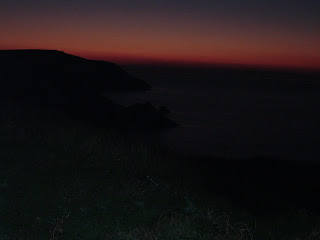 If only I had got here an hour earlier I might have seen a spectacular sunset.
It had been probably the longest, possibly the most gruelling stretch of my journey so far. It was nonetheless enjoyable seeing the hamlets (don’t think we actually had any villages today!) of this wild and little known part of Cornwall. It’s the end of 2006 and I have done five stages. At this rate, it really will be a lifetime thing.
Day five stats:
Places visited: nine (total 35): Millook (GR 184000); Tregole (193980); Trewint (186974); Newmill (216988); Bangors (208995); Poundstock (202994); Treskinnick Cross (207988); Bakesdown (247006); Titson (242016)
Altitude gained: 875m (total 2,915m)
Highest altitude: 154m (Trewint)
Total distance walked: 21 miles (cumul 83 miles), 11 on-road (cumul 47), 10 off-road (cumul 36)
Started walking 9.15am. Finished walking 5pm.
Map used: OS Explorer 111
Interesting links:
http://www.thisisnorthcornwall.com/poundstock.html
http://www.north-cornwall.co.uk/villages/village-pages/Poundstock.htm
http://www.bangorsorganic.co.uk/
Photos of Millook: http://www.westcountryviews.co.uk/coastal/millook/millook.htm
posted by Dan @ 22:33
![]()
![]()


0 Comments:
Post a Comment
<< Home